It is hard to believe that it has been over a year since Jeramy, Mark and I set off from the California-Mexico border in hopes of walking the 2,600-plus miles to Canada on the Pacific Crest Trail. With no way of knowing what adventures or mishaps we would encounter and in anticipation of the journey ahead we began our hike in the early evening of April 29. Now, over a year later I find myself looking back gratefully and, at times, longingly at those months spent living, experiencing and walking some of what is left of the West’s wilderness. Jeramy and I finished the trail on October 13 in the cold yet beautiful snows of northern Washington, bringing to an end a spectacular journey.
Since that time we have moved to Portland, Oregon and have been lucky enough to find work that we each enjoy. We have also been lucky enough to enjoy a few more adventures on the PCT. Shortly after finishing our hike we headed back to southern Oregon to complete a stretch of trail we missed due to Jeramy’s foot injury. In late October last year we struck out again, this time walking south from Ashland, OR, with the intention of hiking roughly 100 miles back to where we reluctantly got off the trail just 20 miles shy of Etna, CA in August. It was wonderful to be out there again, after only two weeks off trail I already had begun to miss it. Although this hike did not end as we would have liked, it eased our transition back into the rhythms and realities of life in “civilization”. Our temporary home under the bridge
 Northern California
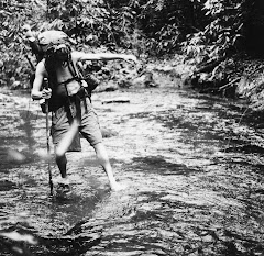
The hike itself was gorgeous, particularly hiking down into Seiad Valley and up out of the valley into the Marble Mountains. Our first night out of Seiad the rains came, it poured all night and continued into the next day. We walked along exposed, windy ridges, rain drenched and cold-to the point where fingers and hands were incapacitated and useless. This was not what I had hoped for. I had enough of the wet and cold in northern Washington. Fortunately the day we set out from Seiad Valley, hiking up the road to the trial head, we ran into a ranger who told us of a side-trail down off of the ridge should the weather turn. We reached this junction in mid-afternoon the first day of the storm and knowing the trail stayed up on the ridge for miles to come and that the storm was to continue and possibly get worse we-somewhat reluctantly-decided to head down. We hiked five miles down, though cow-grazed lands, and came to a seemingly abandoned road. We had hoped to hitch a ride out that evening but given the lack of traffic and the encroaching darkness the nearby bridge became more and more appealing. Crossing the bridge we followed the stairs down underneath. To our surprise there was a sandy and dry spot directly under the middle of the bridge. Watching the rainfall we set up camp and ate dinner. Grateful for protection from the elements we slept soundly-and dry. The next morning we easily hitched a ride out and made it to Yreka. That was our last experience on the trail until April of this year. PCT class of 2008
 At the border....again
Every year the official beginning of the thru-hiking season is marked by the Annual Day Zero PCT Kick-Off (ADZPCTKO). The kick-off takes place the last weekend of April at Lake Morena County Park, twenty waterless miles into the trail. It consists of hundreds of hikers, past, present and future gathering to celebrate, learn and share knowledge of the PCT. We did not attend last year and decided to check it out, knowing that we would see many of the friends we made last year. It was a wonderful reunion where we reconnected with many fellow hikers, including, Marty McFly, S.O.L, Jester, Rat, Coyote, HR Huff & Puff, Smooth Criminal, High Octane, D-card, Jessica, Squatch, Mssing Link and many others. I almost felt as if I was back on the trail, except for the fact we were sedentary, although Jeramy and I did manage to get a little hiking in.
We spent two nights hiking the first stretch of trail we missed last year due to a fire. At the time we were disappointed, not only that we would be missing some of the trial, but also because it is the first time the trail climbs out of the desert into the mountains. Before the climb
 So nice to see Yucca's again
The San Jacinto Mountains rise over 9,000 feet above the scorching desert floor and snow can remain in there through May, shaded by tall Ponderosa, Jeffery and Coulter Pines. We had looked forward to the transition and witnessing the subtle yet substantial changes that take place in the land as it moves vertically upwards, from desert to mountain.
We were very thankful to find the time to hike this thirty miles stretch of trail while in Southern California. It wonderful to be back on the trial, remembering the way it moves, slow and winding through the land, meandering almost. Remembering the sounds of birds, feet against dirt and rocks, walking with the sun, sleeping with the moon, days determined largely by where our next crucial life source could be found- water. In the evening, feeling our worked bodies as we sat down to eat a much anticipated and appreciated meal.
All of these feeling and memories came back in those two short days, bringing with it nostalgia. But being “out there” also brought back the challenging and trying mements too. Blistered feet, stifling heat, steep and difficult climbs, cold hands and feet, monotonous meals. Though somehow all of the physical and emotional challenges could never out-weigh the beauty and joy of such an experience. I suppose all of the difficult times are a part of what makes it all the more amazing and wonderful. I don’t think we can truly have joy without the flipside, hardship and pain.

And so our short excursion back on the PCT was as I had hoped it would be, amazingly beautiful yet challenging. The changes in the landscape from chaparral, cacti, lizards, and sand to pine and fir trees, boulders, snow, cliff ledges, and mountain springs all in a days walk was astounding. We also met a handful of current thru-hiker hopefuls. One man whose son had hiked it last year and whom we had known, another from Portland, OR. We shared stories from our experience and their excitement and anticipation of the journey ahead was infectious.
We ended our hike in the quaint, friendly town of Idyllwild, a lone mountain town surrounded by desert and a get-away destination for those in the valley. We stopped at the local food Co-op that we had discovered last year and grabbed a few snacks before hitching out of town, down into the heat. It took some time to get a ride, though not for lack of willing people, but rather that we were going further than they. Eventually we got a ride with a man, around our age, who was getting ready to hike the trail in a few weeks and was checking out trail towns, as they are known. He said there would be a film crew with him following and recording his journey. The trail never lacks interesting folk.
We made it to Interstate 10 where, after missing the last bus towards L.A we called our friends there who kindly came and picked us up.
And so we ended another stint on the PCT, though future plans will no doubt be hatched as we still have 150 miles left to hike in central and northern California before we can truly say we walked from Mexico to Canada:) Until next time.
Happy trails.
Thursday, June 11, 2009
A Year Later
Monday, October 27, 2008
high adventure in the north cascades
 bobby lake
 golden tamaracks
 at the border
from the dried out desert heat and million wildflower shades of a southern california spring to the drenched-bright temperate forest fall on into the early winters of the rugged north cascade mountains, all the days, seasons, and changes that have unfolded on this winding old journey through the western landscape.
we set out into washington during a late summer warm spell, a week of clear blue skies and hot days as we moved north from the columbia gorge and past the cascading ice glaciers of mt. adams and the high peaks and passes of the goat rocks wilderness area. sitting beside lakes and in clear streams and high meadows, walking old forests, the alpine lit up with crimson blueberry fields and yellow-tipped grasses. we were thankful for the sunshine and realized it would be fleeting and surely it wasn't long before the rains came tumbling down, emptying from the skies as great billows of cloud covered and uncovered the mountains. in the central cascades the rain poured and we walked a landscape pocked with clearcut after clearcut, thick brush and young tree plantations soaking us to the bone as we pushed through. masses of huckleberries, douglas fir saplings, fungi emerging from intricate mycelial webs, our dripping raingear, the gray rains indifferent and drenching it all. howling out on the exposed western flank of blowout mountain, the wind pelting us, cloud vapor whipping by and we only could keep moving and accept the water, breathe in the cold, wake up in the morning, put on the wet layers and start it all again. eventually we passed through the cuts, returning to the cover of the old conifer forests, dark tree-tops cutting through the fog, western hemlock and red cedar canopies providing shelter, broad golden devil's club leaves catching the drips, vine maple all vivid yellow and red, the bracken ferns browning and fading.
further north we moved into the roadless areas of alpine lake and glacier peak wilderness. climbing and descending deep valleys cut by the sharp gray-blue fingers of glacier peak. its churning silt rivers leaving powerful marks on the land; thousands of scattered trees and massive swaths of disappeared riparian slopes that were sent tumbling to the sea during the devastating "1,000 year flood" of november 2003.
for the finale it was high adventure in the north cascades, waiting out 72 hours of snow with the wonderful people of mazama and winthrop, returning to rainy pass under clear blue skies, kicking through powder drifts, the cold sunshine bright on the peaks, silent old spiraled black stones glistening with the snows, wind rumbling by. we slowly walked a blank still trail unmarked by humans, only broken by the traveling tracks of the local inhabitants; deer, elk, cougar, coyote, bear, and scrambling chipmunks. three days of breaking trail, exhilarated, mindful, cold, and ecstatic along the open ridges and golden tamaracks, raptors sailing in the winds, enveloped by silence. our last full day out we climbed up to the crest of high lakeview ridge as the orange-red sun began to sink behind the mountains and lit the path. reaching the crest we see the near-full moon rising above jagged three fool's peak, its purple-blue light meeting the fading sun, and the whole land so lucid and beautiful, stone peaks, the steep valleys and rivers descending ocean-bound far below, amazed and humbled by the immensity, by the howling is-ness of it all.
what a process and experience to be able to take part in, reflecting on all the places and people and feeling so grateful for the opportunity. we crossed into canada the next afternoon, october 13th, spent a few hours at the border monument reading the register entries of friends and realizing the walk had come to its resolution. since then we've had warm, dry nights in hostels and the homes of friends and family, sitting beside woodstove fires considering the dark snowy mountains and blowing winds of the cascades and our friends still hiking there.
countless thanks to everyone who has participated and helped in the process of this trip. it has been wonderful to hear from you and to have your support along the way. many thanks to all who made the fundraiser a success as well, together we have raised over $2,000 and counting, closing in on raising $1 for every one of the 2,500 plus miles that we've walked.
today we are setting out for ashland to walk one more stretch of this trail, from southern oregon into california's marble mountain range. thanks to all, and we'll send an update when we have a chance. peace, jeramy
for many more pictures check out www.walkforwild.blogspot.com, and anyone still wishing to contribute to the fundraiser may do so at www.walkforwild.org
Thursday, October 23, 2008
The End?
At the border

Snow capped mountains from Grasshopper Pass
Jeramy at Cutthroat Pass, looking cool!
Bridge washed out in 2003, White Chuck River
Jeramy crossing the Suiattle River
Jeramy in Goat Rocks Wilderness, Mt. Rainier in back
Goats in Goat Rocks Wilderness
We have been finished hiking for 10 days now. Jeramy and I strolled up to the US-Canadian border on October 13th. It was a typical Northwest October day, cloudy and chilly with intermittent rain. Walking up to the wooden Northern Terminus monument was almost surreal. I had envisioned doing so countless times over the last 51/2 months. As I stood in the drizzling rain I looked back to the day we set off from the Southern Terminus monument, full of excitement to begin this journey, a little nervous knowing I would at times be miles from the comforts of modern day existence. "What if something happened out there? What if one of us broke our leg/ankle/etc.?" I mused. Despite my apprehension I knew I wanted to do this, I knew the experiences and memories would be worth all of the struggles, blisters, intense heat, huge climbs, rattle snake encounters, freezing cold nights, numb toes and fingers, etc, etc. I was not disappointed, it was well worth it, all of it.
I can look back on various journey's I have taken in my life, challenging situations I have intentionally placed myself in, knowing that the energy and hard work put into it will ultimately (hopefully) benefit others and myself. I have never regretted any of those experiences though some have left me wounded by the harsh realities and injustices I have witnessed. I am not one to pass up a challenging opportunity and this hike will be added to that list.
Our last few days out were some of the most exciting and nerve racking of the entire trip. We left the last town of the trail, Stehekin, and hiked 20 miles only to be forced off the trail by a freezing rain turned snow storm. Luckily we came to the last major road on the trail when the storm hit. We holed up in the only shelter available there, a small concrete trailhead restroom. As we stood there trying to warm up and eating the amazing pastries from the famous Stehekin bakery we discussed our options. Should we spend the night in the restroom? Set up camp where we were? Or try to hitch into town? The one thing we did know was that we did not want to continue hiking that day despite the fact that it was only noon. If we did we would climb up another 2,000 ft. and with 3 inches of snow fallen in an hour and a half that did not seem like an intelligent idea. Our decision was made easier when a man taking his new jeep for a test ride in the snow showed up outside our bathroom/shelter door. He knew exactly what we were doing and he chuckled to himself at the thought of us waiting out the storm in the bathroom. He gave us coffee to warm our hands and our insides and offered us a ride to the nearest town. In our stubbornness we could not make up our minds, though after sitting in his jeep warming my hands on the heater we decided that it was absurd not to accept his offer.
The closet town, Mazama, was 15 miles from the trail. It doesn't consist of much, a few hotels nestled in the trees and a general store that also serves as the town hub. Winthrop was another 15 miles further east, we had the chance visit both in our three days of waiting out the storm. Of all the towns on the trail these two are among my favorite. Some of the most friendly, kind-hearted people I have met live there. Getting around and between the two towns required no effort in spite of there being no public transit. I think we got 7 rides in total, not a single one did we stick a thumb out for. People offered us rides before we could even get that far and when we weren't even looking for rides. Brian, the owner of the independent bookstore in Winthrop, hiked the PCT in 1997 and after talking with him for a few minutes he offered to put us up for a night while we waited to go back out. Along the entire trail we experienced this, what is called "trail magic;" generous, giving folk who go out of the way to help out hikers. It never ceased to amaze me how many people we met along the way who offered up their time, energy and resources to help out the folks they saw walking around their towns looking slightly lost with a pack on their backs.
So after three days in Mazama/Winthrop waiting and discussing our options for finishing the trail we decided to take advantage of three days of good weather and go for it. Unsure of how much snow there would be up there or whether we would be able to see the trail well enough to follow it we bought some warmer gear and a few extra maps, we were as prepared as we could be. All we needed was for the weather report to be accurate.
When we got back to the trailhead at Rainy Pass there was more snow than there had been when we chose to bail out three days prior, but not enough to detour us, we were determined to finish. We were only 70 miles from the end! The first five miles were disheartening, it took us three hours to hike it. To give you a sense of how slow that is we usually averaged three miles an hour. So hiking a normal pace in those three hours we should have been able to cover nine miles, not five. Not very promising if we were to finish in the next three days before another storm came through. Yet we could see the trail ahead of us and it seemed that the snow, which had been up to our knees in parts, would not be that deep the entire way. Besides, it was absolutely gorgeous. Bright blue sky behind snow covered, craggy peaks on all sides. Not a sound, nor a foot print save for the occasional deer or elk track. We slowly pushed on, Jeramy in the lead breaking trail (making it significantly easier for me). With each ridge we crossed we could see the trail stretched out ahead of us and the chances of getting through in time became more and more likely. As we descended into the first valley we began to see more and more animal tracks, deer, elk, coyote, and cougar. Still no human tracks. At no point, other than the one road we crossed between Rainy Pass and trails end did we see other people. Just us, the mountains, snow, beautiful tamarack trees changing color and a consistent trail of animal tracks, of which I should add bear to the list.
The weather was on our side the entire time (minus the cold). We had beautiful sunny days with occasional cloud cover. Two of the three nights it rained/snowed slightly but nothing that significantly affected us. Those three days and nights were arguably some of our coldest on the entire trail. Of course we expected this when we set out from Rainy Pass, but anticipating cold is much different than experiencing it. Nature is unrelenting and unbiased. Not malicious, simply alive. And it will remind you that you too are alive, and to not take your life for granted. I was grateful not to be there alone. The coldest night of the three we cooked our dinner of instant mashed potatoes, spiced it as we like and by the time we got around to eating it was almost cold. It is always easier to deal with challenging circumstances together rather than alone, and I was grateful that I was eating cold mashed potatoes with Jeramy and not by myself.
Our last day full day out we hit the highest point on the trail in Washington, around 7,200 ft. Our goal was to make it over and down before Monday when the weather was suppose to turn again, we succeeded in that and saw one last amazing sunset. As we reached the high point the sun was setting. It was picturesque, only a few clouds in the sky, enough to tint the sky orange, yellow, and pink. To the east the moon was rising, almost full. We would have considered camping up there had there not been 2 feet of snow on the ground and completely exposed. We walked by the light of the moon down to the lake below and found a nice sheltered spot among the trees next to the half-frozen Hopkins Lake.
The next morning we had 15 miles to walk until we reached Manning Park, the end of the trail. We took our time, knowing it was our last day out. Eight miles before the end we reached the US-Canada border where the official end of the PCT is marked with the Northern Terminus Monument. We spent a few hours eating lunch, reading the entries that all our friends who had finished before us had written in the register, and doing a bit of a photo shoot. Usually I would not brag but since it was such an epic adventure I have to say that we were the first people to sign the register at the border in a week. Our friends had been the last ones to sign it on October 6th. Meaning that nobody had hiked through that storm and we were the first to do so after it hit. We had hoped that another couple that we had been hiking on and off with since southern California was right behind us but when we got into Manning Park we learned that a ranger had talked them out of hiking the final stretch.
Now here I am sitting on the couch wrapped up in warm clothes, inside my warm house, typing away on my computer and looking out the window at the beautiful, sunny day and trying to get used to the idea that I will not be spending the majority of my time outside contending with the elements and experiencing the seasons as they come and go. Remembering as I sit here not to take anything for granted. Whether it be shelter, warmth, dryness and a bed, or rain, sun, snow, hail, thunder, lightening and on and on.
We began walking April 29th, spring time, walked into the summer in the high Sierra's and continued the summer in the Cascades, fall came upon us quickly in the middle of Washington and by the end it felt like winter up there. I will miss the trail and the friends made on it. I will miss seeing the changes in the landscape and how it all folds into each other. It is hard to say that I will miss walking through miles of clear-cuts in freezing rain for days at a time, or the 104 degree days down south where it was too hot even sitting still in the shade or to walk in the sand barefoot, or the mornings I woke up with my boots and water frozen, but I will miss those days too.
We hope to get back out there at least one more time this year. We missed a stretch from Etna, CA to Ashland, OR., about 150 miles. Later this week or next, weather permitting, we will head back out for one last hike.
I want to say thank you all for the wonderful support along the way. I especially want to thank Ezra for setting up and maintaining the Walk for Wildlands website (www.walkforwild.org) and getting the word out about the fundraiser. As well as The Kiva and Hummingbird Wholesale, both located in Eugene, OR. We could not have done this hike without the massive amounts of food you helped supply us with. Thank you for your generous donations. Also, Kate, Jody and Rochelle for taking the time to send out the many food boxes that sustained us along the way.
And of course to everyone else, family and friends who provided moral support and encouragement for our hike and to those of you who donated to the Walk for Wildlands fundraiser. Also, if you have not donated but would like to it is not too late, we are still accepting donations. Visit www.walkforwild.org and click on the donate button, and remember to use www.goodsearch.com. Just write Walk for Wildlands as the organization you would like to donate to and each time you do a search they will donate to the project.
Thank you all again. Keep your eyes out for one more entry later next month!
Peace,
Serena
images from southern washington
crossing the columbia: mainesail and serena
walupt creek-goat rocks wilderness 
full moon night mt. tahoma (rainier)
images from oregon
 tunnel falls
mesa creek in sisters wilderness (top) paintbrush blooms


lava field near mckenzie pass (top) jefferson park below mt. jefferson
Sunday, September 21, 2008
some pictures to hold you over
Hi all,
It's Kate again. Jeramy and Serena are now in Washington and are closing in on their final destination. I spoke with Jer the other night and he asked me to post a few more California trail pictures. Also, he asked me to remind everyone that you can easily benefit Walk for Wildlands by using goodsearch.com for any web search (as opposed to Google, for instance) and selecting Walk for Wildlands as your charity of choice.
The hikers may not have access to the internet until after they've completed the trail, but if anyone is currently in the Pacific Northwest and interested in meeting up with them, I'll send you their itinerary - just shoot me an email at myrakatherine@gmail.com.


Tuesday, September 9, 2008
bring on the canucks!
greetings all,
here we are, after all of these days and months of walking we find ourselves on the verge of crossing the columbia river and moving into the final stretch of this wandering journey through the cascade mountains of western washington. gradually, thoughtfully we move through changing landscapes and seasons, the sunlight fading, nights colder, wind with a bite and golden clear fall air surrounding us.
we pushed through northern california, hundreds of wildfires throughout the region and breathing in smoke-haze sky. through dry arid lands and and coniferous stands, weaving around mt. shasta, appearing and disappearing behind smoke blankets in the distance. slowly, daily feeling the change to the more temperate climate of the pacific northwest, dropping into deep ravines and finding the familiar species, tall old incense cedar rising through the mist, thick cracked-bark douglas fir groves, yew trees, moss-draped big leaf maple, sword and maidenhair ferns tucked into the shadows beside cool clear creeks.
near the california/oregon border i pulled up with an ankle injury, a strained tendon that was enough that i wasn't able to put weight on it. we hobbled to the next road crossing to find a fire crew sitting in preparation for the next call. after an attempt at walking on we turned back to catch a ride with a story-filled helicopter repairman. two days later we tried walking again and realized that my foot was going to need some rest. just over a week later we found ourselves in ashland, or with a lighter pack (sans guitar), clad with a new ankle brace, and 140 miles north of where we had gotten off trail (saving ourselves some october hiking). we spent a day with some hiker friends and then set off into the dry afternoon to begin walking again. the time lapse was evident all around us, wildflowers spent and crumbling in the heat, ripe patches of thimble and huckleberries, the days noticeably shorter, even new aches and pains and a seeming loss of our trail legs. within a few days they were back as was the methodical pace of walking and the forest...a slower reality than our high flying days in town and at eugene's indian lunch buffet.
traveling through serena's home region of western oregon, we stepped through the grasslands and forests of the cascade-siskiyou monument. awaking in the dark waning moon night there to the piercing howl scream of a cougar close by. adrenaline rushing and listening intently as it called out many times through the darkness. we spent the majority of two days passing through this landscape where the great basin and cascade and siskiyou mountain ranges meet, a patchwork of private and public lands, not yet funded enough to form a complete monument. days later we watched and listened as the red rising sun climbed over the mountains above crater lake, mats of clouds sailing overhead, incredibly blue marine water interacting with gusting winds and shifting patterns unfolding across the surface. swimming in lakes, rivers, and cold rains, a front moving through and wind driving snow specks as we crossed under the three sisters volcanoes, looking up to the rounded red peak of south sister before she was enveloped by clouds. thick forests, lake basins, renegade survivalist mosquito bands somehow braving the cold, big-berried bear scat, and the massive volcanic cascade mountains. along with this another familiar mark of the northwest, tracts and tracts of clear-cuts, old and new, walking through some active logging operations even, shrill machinery grinding and great old cedars and firs with spray paint markings of doom. we've scratched through these patches of choked brush and even-aged young spindling stands scarring the mountainsides from the trinity region up into oregon national forest and bureau of land management lands.
and now sitting beside the rolling columbia river, as close to sea level as we'll be along this trail, preparing for the washington cascades. with the final push of our hike before us we also hope to close the walk for wildlands fundraiser with success. each of the three projects and organizations will greatly benefit from any contribution, and sponsoring our hike will help to promote the completion of the cascade siskiyou monument through the pacific forest trust, protect the pct trail corridor with the pcta, and work to guide sound policy with the cascadia ecosystem advocates. please consider sponsoring this project at www.walkforwild.org as no contribution is too small or large.
thank you to all who have read, responded, contributed, and helped us along the way! serena and i will update more photos and journals as we are able through the final days of this venture. happy falltime, peace, jeramy
Oregon Walking
Hello all,
I know it has been some time since I have written. There have been many beautiful sights seen and experiences to reflect on in these last few weeks. In late August, after almost four months of walking in California, we finally hit Oregon. Our entrance was a bit anti-climatic as Jeramy had a strained tendon and we had to take some time off for it to heal, thus we were unable to walk across the boarder into Oregon. Never the less it has been an incredible walk through my home state. I had been looking forward to it in anticipation, as there are so many places I had heard so much about and I would finally be able to experience them.
Our first stop out of Ashland was one of the most incredible places in the world, I believe. Crater Lake. Massive, peaceful and breath-taking. We were able to spend a day walking along part of the rim of the lake and spent the night on a bluff overlooking it. In the morning we woke as the sun was rising. One of the most beautiful sunrises I have ever seen. The clouds quickly moved in though and the rest of the day was spent getting glimpses of the lake through the clouds as we stood in the frigid wind. The wind rippling across the water combined with the clouds and sunlight trickling through created a surreal picture. I was hard to leave that place but the cold wind kept us moving. We hiked on towards. Mt. Thielsen, tall, rocky and pointed. We decided against climbing it as it was covered in clouds and probably about 30 degrees on top.
As we approached central Oregon I began to think back to my childhood spent at Waldo Lake in the summers and Odell Lake in the winters. The PCT hits the south shore of Odell lake and we spent and evening at Shelter Cove Resort. The next day we hiked up to Willamette Pass were Jeramy had been hoping to get some pizza for lunch at the ski lodge. Unfortunately they weren't serving food that day and we had to resign ourselves to eating the same old tortilla and cheese wraps for lunch.
The PCT does not pass directly by Waldo lake so I was unable to go swimming at one of most beautiful lakes in Oregon. However it does pass by a myriad of smaller lakes just east of Waldo that I had never seen before, the three Rosary lakes, Bobby lake and others that I can't remember the names of. Our hike between Odell lake and Santiam Pass (Highway 20) also took us past the Three Sisters. WOW! I had never hiked near those mountains before, only seen them from a distance. What gorges mountains. South sister with its red rocks we were able to catch the best views of. It turned out to be quite cold and stormy as we hiked passed the Sisters, but still absolutely amazing. We saw a rather large coyote carrying what appeared to be a rabbit in it's mouth, a huge buck running across a meadow and a grey horned owl.
Luckily we made it down off the Sisters before the worst of the storm hit. As we descended toward McKenzie Pass sleet and small snow flakes began to come down. We stopped by the Dee Wright Observatory and checked out the few mountains that weren't immersed in clouds than pressed on through the lava fields and passed Mt. Washington. We were on a mission to meet my mom at Santiam Pass that evening. The cold aided us in getting there, as it was too chilly to stop for long. Just long enough to stop at the 2000 mile marker and celebrate! I told her we would be there at 7pm and we rolled in at 7:06 pm. It was such a blessing to see her there walking out on the trail to meet us. We went into Bend for the night, got warm, ate some good food and got cleaned up. As seems to happen often in town we ended up staying longer than expected. We visited with some friends who lived there and Tuesday evening (Sept. 2nd.) got back on the trail.
This last stretch in Oregon we hiked passed Three Fingered Jack, Mt. Jefferson and Mt. Hood. All three mountains that I have also seen from a distance but never up close. Jefferson still had quite a bit of snow on it and we hiked over snow banks for the first times since we left the Sierra's way down in California. I imagine there will be more of that to come in Washington as it was such a big snow year. Unfortunately when the snow sticks around so too do the mosquito's. And there were a surprising amount of them for the Cascades in late August.
Our hike between Jefferson and Hood was relaxing and warm. The sun had decided to show her face again and we're hoping to have a few more of these days as we finish this amazing journey though Washington. We stopped at Timberline Lodge on Mt. Hood. You may remember the outside of the lodge from the movie "The Shining". The inside is even more incredible, built some time in the thirties and still looking very much the same. Our good friends Jody and Eli met us up there, brought our food box (thank you to those of you who have been so kind to send us our much needed sustenance) and hiked out with us for a night, we had a huge feast. It's always wonderful to have friends join us out here.
From there we hiked around Mt. Hood than began our decent to the Columbia River gorge. Down we went walking along the ridge with the wind whipping by as the sun set. It was a warmish wind but it was strong and camping was minimal and not too appealing with tall trees swaying above us. So we walked later than usual until we found a semi flat spot out of the wind to sleep.
The next morning we hiked into the gorge and took a detour from the PCT, down the Eagle Creek Trail. One of the most astounding trail in the gorge. Countless enormous water falls, some over 100 ft. tall splashing down into huge clear blue pools below. The trail itself in unbelievable. It was literally blasted into the side of a vertical cliff so at times you are walking next to a ledge that drops off 100 or more feet into the water. They have installed a cable to hold onto as you walk the most dangerous part. And the tunnel blasted through the rock behind a waterfall! Amazing. If you ever have the chance, check it out. And with that to finish up Oregon we hiked into the small town of Cascade Locks, where the Bridge of the Gods spans the Columbia River. Soon we will walk over that bridge and begin the home stretch of our hike. Washington. Only 508 miles to go.
I hope to have to chance to write again before we finish but we may have limited access to technology through Washington.
Remember to check out the website for more photographs and entries as well as to support the fundraising efforts.
You now have the ability to pledge per mile hiked. Check out the new link on the website at www.walkforwild.org
and please pass it along to others.
With love,
Serena
Oregon Walking

 Eagle Creek
 Mt. Hood
 Mt. Jefferson
 Bobby Lake Sunrise
 Crater Lake
 Fog over Crater Lake
 Sunrise over Crater Lake
Thursday, August 14, 2008
Hello all,
We have almost made it to the California-Oregon border and are now in Eugene taking a few days off for a friends wedding and because Jeramy strained a tendon in his right foot. It's good to have a few full days off and give our bodies a rest. Though I look forward to getting back out there! Thank you all for the wonderful support you have shown us through out this journey. I hope you enjoy the photos.
Mt. Shasta from the South
Boiling Lake in Lassen National Park
Just before Sonora Pass

On top of Mather Pass, with the Palisade mountains in the background
Hut on top of Mt. Whitney